-
coverage_demos
coverage_demos
|
|
This directory contains demos that illustrate the AFSIM Coverage capability.
The following top-level startup files demonstrate the various operations as indicated:
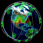
1st_conus_zone.txt
Demonstrates coverage using a WSF_ZONE_BASED_GRID of platforms within CONUS. The zones/conus.txt
file is where the zone is defined, and the gridpoints are spaced according to what is defined in the
grid block. The sat_con satellites are the assets providing the sensor coverage.
2nd_uav_terrain_stepped.txt
Demonstrates coverage using a WSF_DISTANCE_STEPPED_GRID of platforms, which sit on terrain in Colorado.
The gridpoints are spaced with a given distance and locked to a defined origin. The UAV platform flies in an
orbital route to provide coverage. The terrain/uav_coverage_terrain.txt file loads the terrain and draws it
for visualization in Mystic.
3rd_state_zones.txt
Demonstrates a WSF_COMPOSITE_GRID, which is made up of two grids, each of which is a WSF_ZONE_BASED_GRID,
of platforms in the states of Texas and Florida. The sat_con satellites are the assets providing sensor coverage.
4th_lat_lon_global.txt
Demonstrates global coverage using a WSF_LAT_LON_GRID spanning the earth. The sat_con
satellites are the assets providing sensor coverage.
5th_existing_platform.txt
Demonstrates coverage using a WSF_EXISTING_PLATFORM_GRID, made up of five air targets flying West
to East over a ground station. The ground station is the coverage asset providing sensor coverage,
with the ground station sensor tracking the air targets as they move.
6th_geo_belt.txt
Demonstrates coverage of satellites in geosynchronous orbit using a WSF_LAT_LON_GRID.
The satellite coverage assets are made up of the sat_con constellation, with scripts used to point their
respective sensors towards the GEO grid, and a ground station with a stationary sensor. The included SAT
platform has a processor attached checking for exclusion constraints that disallow geometric access and
line of sight to target.


